Let’s be brutally honest: trying to memorize the intricacies of US geography by staring at a flat, color-coded paper map is an exercise in misery. Whether you are a student trying to cram for a 50-states exam, a trivia enthusiast looking to brush up on state capitals, or a road-tripper wanting to actually understand the physical layout of the country, traditional rote memorization simply doesn't stick. The human brain is not wired to remember that the capital of South Dakota is Pierre just by reading it off a list; it needs spatial context, repetition, and interactive engagement.
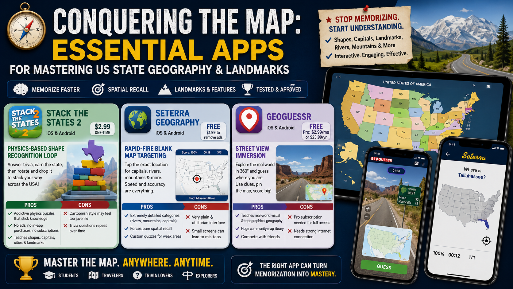
The specific pain point here is synthesis. It is relatively easy to find an app that will flashcard you on state capitals. It is much harder to find tools that seamlessly connect a state's physical shape, its topographical features, its borders, and its famous landmarks into a cohesive mental map.
When we tested the current crop of geography apps on the road—literally passing an iPad back and forth during a long drive down Interstate 80—we ruthlessly eliminated basic digital flashcards and poorly coded multiple-choice quizzes. We demanded apps that forced active spatial recall and visual recognition. We looked for software that penalized blind guessing and rewarded genuine geographic understanding. After weeks of testing, here are the three apps that will actually permanently burn US geography into your brain.
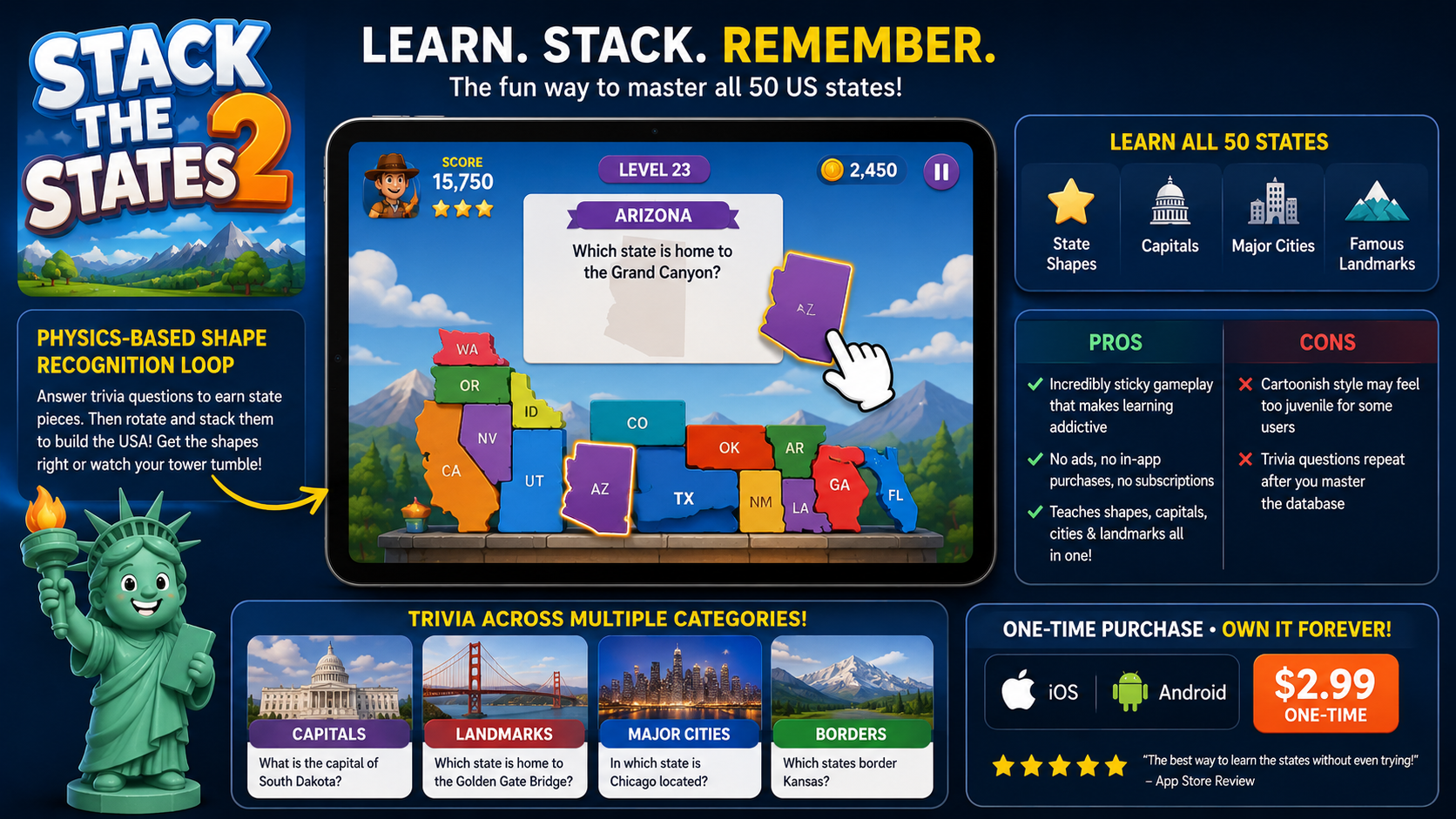
Pricing Model: $2.99 one-time paid app.
At first glance, Stack the States 2 looks like a colorful mobile game designed exclusively for elementary schoolers. Do not let the whimsical art style fool you. It is a ruthlessly effective educational tool that forces you to understand the exact physical dimensions and trivia of every American state.
The core feature that actually works is the Physics-Based Shape Recognition Loop. In most geography apps, if you are asked to identify a state, you tap a dot on a pre-drawn map. In Stack the States 2, when you correctly answer a trivia question about a state's landmark, capital, or bordering region, you are "awarded" that state as a physical, dropping block. You then have to manually rotate and drop that accurately-shaped state onto a platform, playing a Tetris-like game of physics.
When we tested this, we realized the sheer brilliance of the design: to win, you have to subconsciously memorize the exact jagged borders of West Virginia or the flat, blocky dimensions of Colorado so you can stack them without your tower toppling over. It inextricably links factual trivia (like knowing the Grand Canyon is in Arizona) with the physical, spatial memory of what Arizona actually looks like.
Pros:
Incredibly sticky gameplay loop that accidentally tricks you into learning through physics puzzles.
Zero advertisements, zero in-app purchases, and zero subscription fees.
Simultaneously teaches state shapes, capitals, major cities, and famous landmarks in one seamless session.
Cons:
The cartoonish aesthetic and sound effects can feel overly juvenile for adult power-users.
The trivia questions eventually repeat, limiting the app's usefulness once you have mastered the initial database.
Pricing Model: Free basic app with ads; full ad-free version available for a small one-time fee (typically $1.99).
If Stack the States 2 is a playful puzzle game, Seterra Geography is a clinical, high-speed drill sergeant. Seterra has been a legendary staple in geography education for over two decades, and its mobile app transition maintains its reputation as the most granular, no-nonsense map quizzer on the market.
The feature that makes Seterra indispensable is its Rapid-Fire Blank Map Targeting. Seterra entirely strips away the crutch of multiple-choice text answers. When we booted up a specialized US Geography quiz, the app simply presented a blank outline of the United States and barked, "Find the Missouri River," or "Find Tallahassee." We had to physically tap the exact geographic coordinates on the screen.
The app tracks your accuracy and speed down to the millisecond. If you tap the wrong location, the area flashes red, forcing you to try again until you hit the precise spot. Because the app offers highly specialized sub-categories—you can take quizzes exclusively on US mountain ranges, the Great Lakes, or the capitals of the Northeast—it allows you to drill down into the specific regions you are weakest in.
Pros:
Incredibly granular detail; you can learn physical geography (rivers, mountains) alongside political geography (borders, capitals).
Forces pure spatial recall by removing multiple-choice text options entirely.
Allows users to build custom quizzes focusing only on the specific states or landmarks they are struggling with.
Cons:
The user interface is entirely utilitarian and visually dry; there is absolutely no gamification beyond beating your own high score.
Fat-fingering a location on smaller smartphone screens will count as a wrong answer, which can artificially ruin a perfect run.
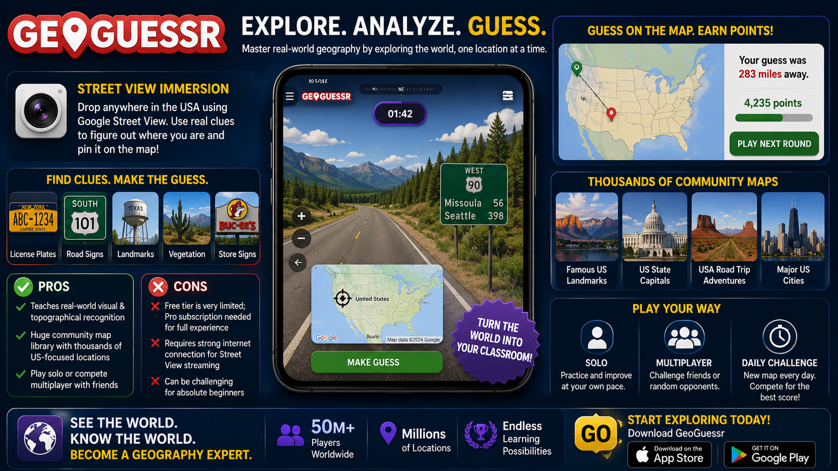
Pricing Model: Free tier with strict limitations; Pro subscription costs roughly $2.99/month or $23.99/year.
Memorizing the name of a state's capital is one thing; being able to visually recognize the topography, flora, and highway infrastructure of that state is an entirely different level of mastery. GeoGuessr has exploded in popularity as an internet phenomenon, but it is secretly the most powerful tool available for learning the actual, real-world visual landscape of the United States.
The core feature here is Street View Immersion. Instead of looking at a 2D map, GeoGuessr drops you into a random, 360-degree Google Street View panorama somewhere in the United States. Your job is to figure out exactly where you are and pin it on a map.
When we tested this on the road, it completely changed how we viewed geography. We were dropped onto a dusty highway and had to actively look for contextual clues. We learned to identify the distinct yellow license plates of New York, the specific shape of a Texas state highway shield, and the difference between the pine trees of the Pacific Northwest and the scrub brush of the Southwest. Users can select community-made maps that focus entirely on "Famous US Landmarks" or "US State Capitals," turning the app into an incredibly immersive, first-person scavenger hunt.
Pros:
The only app on the market that teaches genuine visual geography and topographical recognition of the American landscape.
Massive community-driven map library allows you to play thousands of specialized US-centric locations.
Multiplayer features allow you to compete directly against friends to see who can identify a US landmark faster.
Cons:
The free tier is heavily restricted; a recurring Pro subscription is practically mandatory for a smooth, unlimited experience.
Requires a strong, persistent internet connection to stream the Street View imagery, making it useless in airplane mode or deep in the wilderness.
Choosing the best app ultimately depends on what kind of geography you are trying to master.
If you are a student simply trying to survive a test on the 50 states, their capitals, and their basic shapes, Stack the States 2 is the undisputed champion. Its one-time $2.99 price tag and brilliant physics-based puzzle mechanics make memorizing dry trivia weirdly addictive.
However, if your goal is absolute, comprehensive geographic mastery, Seterra Geography is the absolute best app for this specific scenario. It doesn't hold your hand. By forcing you to repeatedly tap the exact coordinates of rivers, mountains, and capitals on a blank map, it burns the true layout of the United States into your long-term memory faster and more accurately than any other tool we tested.
